Navigation Skills Every Explorer Should Know
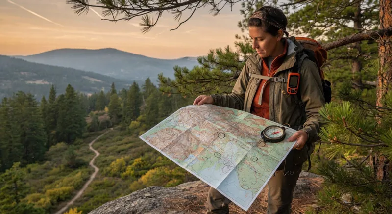
Strong navigation skills can turn an uncertain outdoor journey into a confident adventure. Whether you are hiking, backpacking, camping, or exploring unfamiliar terrain, learning to read a map, use a compass, interpret landmarks, and manage GPS tools helps you travel safely and make better decisions.
Why Navigation Skills Matter
Trails can become unclear, weather can reduce visibility, and electronic devices can lose power or signal. That is why experienced explorers use more than one navigation method. A topographic map and compass remain dependable essentials, while GPS devices and smartphone apps add speed and convenience when used correctly.[2][3]
Navigation is not only about finding your destination. It also helps you estimate travel time, recognize hazards, choose alternate routes, and return safely if conditions change.
Learn to Read a Topographic Map
A topographic map shows the shape and features of the landscape. Before leaving, study the map so the terrain feels familiar before you encounter it in person.
Key map features to understand
- Contour lines: Lines close together indicate steep terrain, while widely spaced lines usually show gentler slopes.
- Elevation: Contour intervals reveal how much the land rises between lines.
- Scale: Map scale helps estimate the real distance between your location and a destination.
- Symbols: Learn the markings for trails, roads, rivers, campsites, buildings, peaks, and boundaries.
- Landforms: Ridges, valleys, saddles, cliffs, and drainages can help confirm your position.
Always check the map’s legend, scale, contour interval, and date. Trails, roads, and natural features can change over time.
Master Compass Navigation
A compass is useful only when you know how to use it. Practice at home or in a nearby park before depending on it in the wilderness. A basic compass can help you orient a map, take a bearing, follow a heading, and estimate your position.[1][5]
How to orient a map
- Place the compass on the map with its direction-of-travel arrow pointing toward the top of the map.
- Rotate the compass housing so its north marking aligns with the map’s north.
- Turn yourself and the map until the compass needle aligns with the orienting arrow.
- Compare nearby terrain with the map to confirm that the map is correctly aligned.
Keep the compass level and use it away from metal objects, vehicles, and electronic equipment that may affect the magnetic needle.[2]
Take and follow a bearing
To take a bearing, place the compass edge between your current location and your destination on the map. Rotate the bezel until its orienting lines match the map’s north-south grid lines, then read the bearing at the index line.[1]
In the field, hold the compass flat and point the direction-of-travel arrow toward your destination. Turn your body until the magnetic needle rests inside the orienting arrow. Choose a visible landmark along that line, walk to it, and repeat the process. This technique is more reliable than staring at the compass while walking.
Understand Magnetic Declination
Map north and magnetic north are not always the same. The difference is called magnetic declination, and it varies by location and changes gradually over time. Check the declination information printed on your map or from a trusted local source before setting a precise compass bearing.
Ignoring declination may create a small error at first, but that error can become significant over a long distance. For casual trail walking, terrain awareness may compensate; for precise backcountry navigation, adjust your bearing properly.
Use Landmarks and Natural Navigation
Landmarks provide valuable confirmation between compass checks. Look for distinctive peaks, lakes, bridges, ridgelines, rock formations, roads, and stream crossings. Compare what you see with the map rather than assuming the first familiar feature is your location.
Natural navigation should support—not replace—map and compass skills. Sun position, stars, prevailing terrain, and visible landmarks can offer clues, but clouds, dense forest, seasonal changes, and unfamiliar landscapes can make them unreliable.
Use GPS Without Becoming Dependent on It
GPS receivers and navigation apps can display coordinates, track progress, and guide you toward stored waypoints. They are especially useful for recording a route, locating a campsite, or checking distance to a destination.[4]
However, GPS signals may be weakened or blocked by terrain, vegetation, buildings, or surrounding objects. Batteries can also fail, and downloaded maps may be incomplete.[6]
- Download offline maps before leaving.
- Carry a backup battery and charging cable.
- Learn how to read coordinates and use waypoints.
- Record important locations such as trailheads, campsites, and water sources.
- Carry a physical map and compass as a backup.
- Practice using the device before your trip.[3][4]
Plan Routes Before You Start
Good navigation begins before the journey. Study the route, identify difficult sections, and estimate travel time based on distance, elevation gain, terrain, weather, and group ability.
Mark decision points where you may need to choose between trails or turn around. Share your itinerary with a trusted person, including your route, expected return time, vehicle location, and emergency contacts.
Recognize When You Are Lost
Confusion becomes dangerous when explorers continue moving without a plan. If the landscape no longer matches the map, stop and avoid making the situation worse.
- Pause and stay calm.
- Identify the last confirmed location.
- Check your map, compass, GPS, and recent landmarks.
- Retrace your steps only if the route is clearly safe.
- Stay put if returning is uncertain or conditions are deteriorating.
- Use emergency communication tools when necessary.
Practice These Navigation Skills Regularly
Confidence comes from repetition. Practice map reading, compass bearings, coordinate entry, distance estimation, and route correction on short local walks. Try navigating without following a marked trail, then compare your position with the map or GPS afterward.
The best explorers combine traditional skills with modern tools. By learning topographic maps, compass navigation, GPS basics, landmark recognition, route planning, and lost-person procedures, you gain the practical judgment needed to explore more safely and confidently.
References
You May Also Like
 Travel
When Tourism Helps Protect Fragile Places
 Travel
Citizen Science Trips That Welcome Travelers
 Travel
How to Choose Responsible Nature Experiences